/
SCROLL

HIKING

Hiking is a wonderful way to experience nature. It allows you to see both the grand and the minute details that appear along the trails. Your chances of encountering wildlife increase when you travel on foot and can move in silence. A hike doesn’t have to mean a full backpack and multiple day stages; even a morning trip around the corner can be enough. That’s the charm of it – you can tailor the day to your own wishes. Be sure to plan your trip so there’s time to enjoy it! A tip is to bring a backpack. That way, you can pack a thermos with something warm to drink and some snacks so you can sit down and enjoy without having to turn back just when it’s most beautiful and your stomach starts to rumble. Around Björkliden, there are plenty of tours suitable for a day trip.

There are also opportunities for longer hikes, but here we’ve chosen to focus on what’s available in the immediate area. If you’d like tips and advice on longer bookings, please contact our guides or the booking office.

Good complements to bring for an even more enjoyable trip in the mountains include a map so you can identify what you’re looking at, binoculars and a magnifying glass to get a closer look at wildlife and birds, and a flora guide to identify the vegetation around you. Keep in mind that with today’s technology, there are also good apps for your phone, such as “Norrbottens naturkarta” (Norrbotten Nature Map) and various digital flora guides that can help. However, we always recommend carrying an analog map and compass with you when you go out on a trip.

1. Navvy cemetery (Rallarkyrkogården)

Hike the old railway construction road through the lush mountain birch forest and imagine yourself back to the turn of the last century. Enjoy the small waterfalls and the abundant greenery surrounding the path, as well as the peace and beauty of the Navvy Cemetery (Rallarkyrkogården). Imagine the destinies this historic place has witnessed – let yourself be captivated by the mystique surrounding the woman known as Svarta Björn (Black Bear)! You can read about her at the cemetery.

”The Rallarvägen is a fun trail to cycle. Rent a bike for a day and discover a different mountain adventure!”

Start at the hotel, take the cabin village road or the asphalt road down to the railway station in Björkliden village. Cross the railway at the railway crossing and immediately turn left. At the edge of the forest, you’ll find an information board about Rallarvägen and a road sign. From here, it’s about 3.5 km to the Navvy Cemetery. The cemetery itself is on the left side above the path; there’s an information board at the trail intersection. If you want to visit Tornehamn Church, follow Rallarvägen straight past the Navvy Cemetery and look for signs towards Tornehamn. It’s about a 1.5 km hike down to Tornehamn from the cemetery. Turn around and take the same path back to the hotel.

    FACTS ALTERNATIVE 1

    Distance:

    8 km Hotel – Navvy cemetery and back.
    3 km Navvy cemetery – Tornehamn and back

    Time required:

       2-3 h

    Marking:

      White-blue markings on tree trunks. Signs.

Follow alternative 1 to the Navvy Cemetery (Rallarkyrkogården) and then choose to hike up towards the crater lake, about 1.5 km. Then, do the hike to the crater lake in reverse back to the hotel – see separate description. If you choose this option, you’ll walk up towards the cemetery, but instead of going through the gate, follow the outside of the fence up to the railway. Be careful when crossing the railway; trains can approach quickly! On the other side of the railway, there’s a path directly up the forest slope – follow this.

    FACTS ALTERNATIVE 2

    Distance:

    9 km (church not included)

    Time required:

    3-5 h

    Marking:

    Rallarvägen is marked with blue and white signs. The path up towards the crater lake is marked with a few red trail crosses.

2. Crater lake (Kratersjön)

Are your legs itching for vast mountain expanses and incredible panoramas? Kratersjön (Crater Lake) is surrounded by lovely rock slabs perfect for resting your legs and enjoying a thermos of coffee you brought along. On the mountain plateau, you’ll find typical mountain plants creeping along the ground and likely some scattered reindeer grazing in front of the peaks. In clear weather, you’ll see all the way to the Norwegian mountains and, of course, the magnificent Lapporten! If the weather is warm, a dip in Badsjön (Bathing Lake) can be refreshing.

Start at the hotel and head up the steep gravel hill towards the golf course. Hike up the gravel road, and after about 1.5 km, you’ll arrive at Badsjön. Follow the path on the north (right) side of the lake. After about 2 km, you’ll reach Kratersjön. Here, you’ll also find a wind shelter to enter in case of bad weather. Stay on the path if visibility is poor! If you wish, you can choose to turn north (right) at Kratersjön and hike the 1.5 km down to the Navvy Cemetery (Rallarkyrkogården). Be careful when crossing the railway! From the Navvy Cemetery, you can follow the Rallarleden (Navvy Trail) along the railway back to the hotel.

    FACTS

    Distance:

    7 km Hotel – Krater Lake and back.

    Time required:

    2-3 h

    Marking:

    Red trail crosses begin on the right side of Badsjön.

3. Silver Fall (Silverfallet)

Follow the Rakkasjohka stream down towards Lake Torneträsk to one of Björkliden’s classic hidden gems, Silverfallet (Silver Fall). Here, the stream plunges into a narrow canyon that empties into Torneträsk. Stroll along the beach and feel the smooth stones polished by the water. If you want to cool off, a quick and refreshing dip in the clear water is recommended, but it’s not for the faint of heart!

Start at the hotel, walk towards the ski slope, and follow the path that traverses Teknikbacken. The path leads into the forest and towards a large wooden kåta (traditional Sami hut) called Lavvon. Pass Lavvon and head straight down towards the stream. Do not cross the stream; instead, turn downstream and follow the stream towards Torneträsk. After a while, you’ll reach the lift houses and the helicopter pad. Here, you’ll need to turn onto the asphalt road for about 150 meters. At the intersection, you’ll have the stream right next to the road and a bridge over the water. This is where Rallarvägen towards Abisko begins. Stay on this side of the bridge and turn down along the stream. There’s also a path down towards Silverfallet along the stream’s edge – take this! The path goes under the E10 highway and down towards the water. There’s a bridge over the stream a bit further down. Watch out, it can be slippery if it has rained! Now you’ve arrived at Lake Torneträsk!

    FACTS

    Distance:

       3 km Hotellet – Silverfallet t.o.r.

    Time required:

       1,5 h

    Markering:

      The path is unmarked, but there are clear trails and roads.

4. Låktatjåkko Mountain Lodge

Låktatjåkko Mountain Station, or “Låkta” as we call it, is Sweden’s highest located mountain station, at 1228 meters above sea level! The mountain station is spectacularly situated in a pass between two mountain peaks, nine kilometers from Björkliden. From here, you have miles of panoramic views over Lapland’s magnificent mountain world. A visit to Låktatjåkko Mountain Station to eat a legendary Låkta-waffle is well worth the effort. The hike itself offers fantastic views. First, over Lake Torneträsk on the way up Mount Namnlösa (The Nameless Peak), then the mountain plateau Rákkasláhku spreads out. The final stretch offers a bit more climbing before you reach the Mountain Station.

FACTS

Distance:

   About 9,5 km

Time required:

   3-5 h (one-way)

Marking:

  Red paint markings on cairns for the Guide’s Trail, cairns for the Summer Trail.

Elevation gain:

   About 750 m.

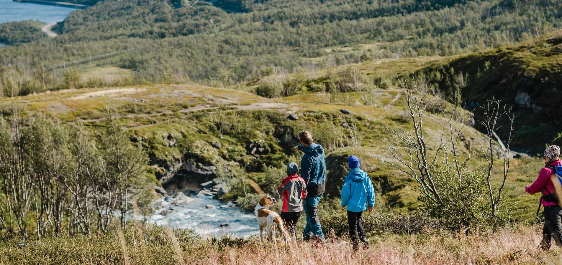
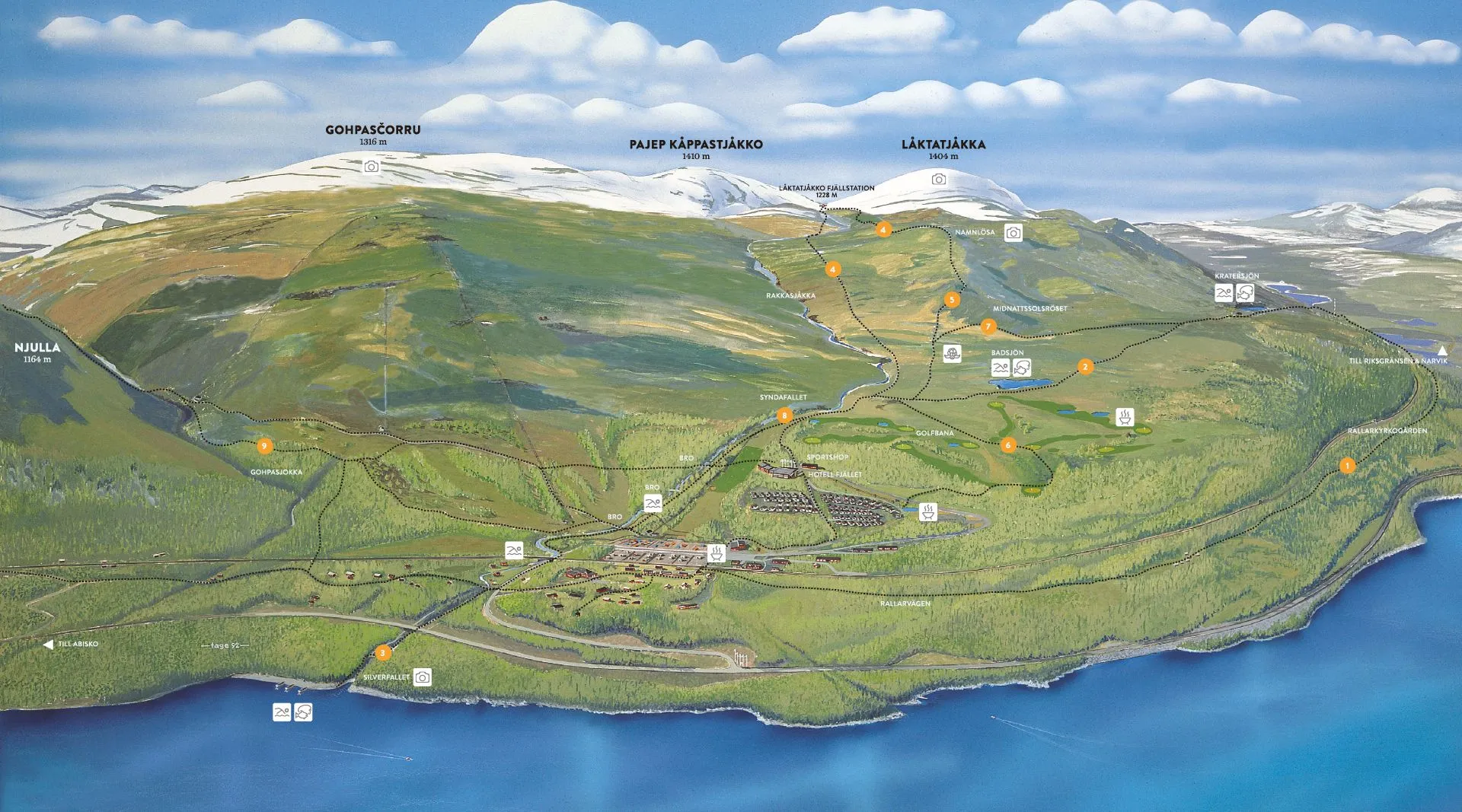
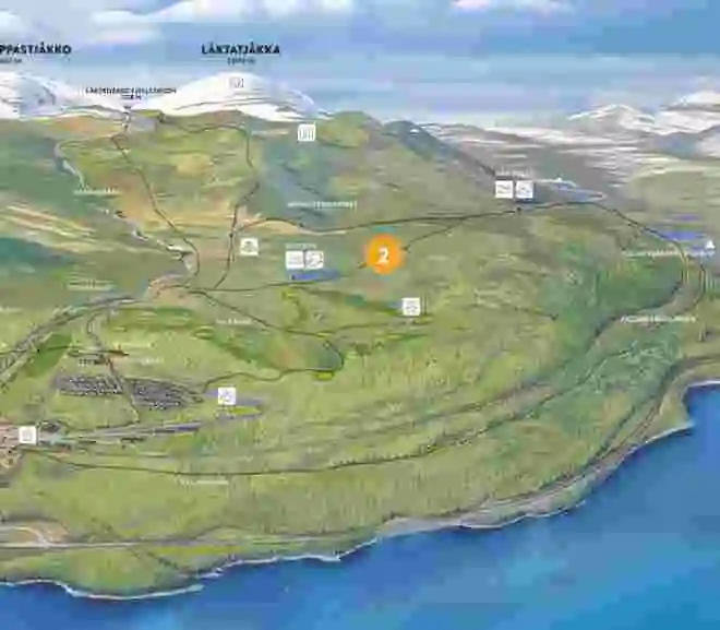
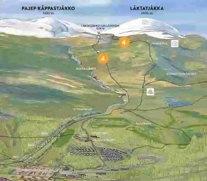
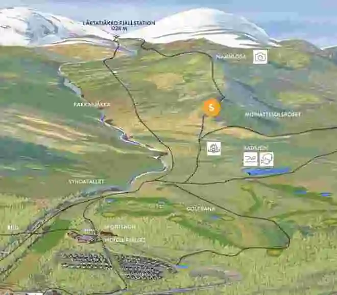
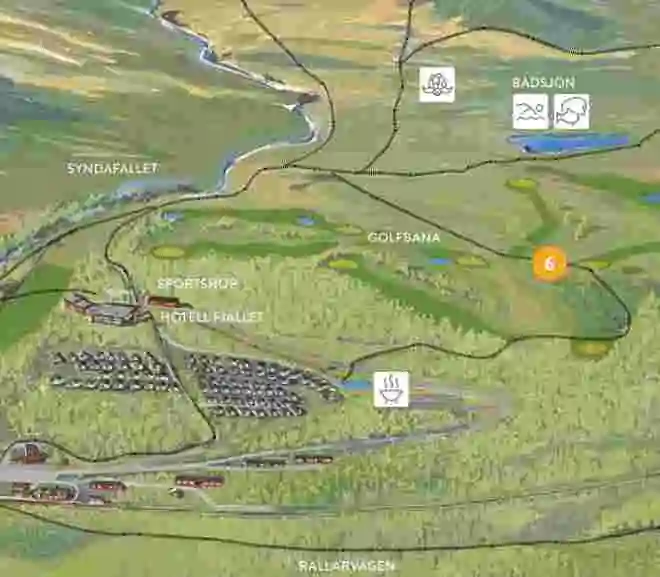
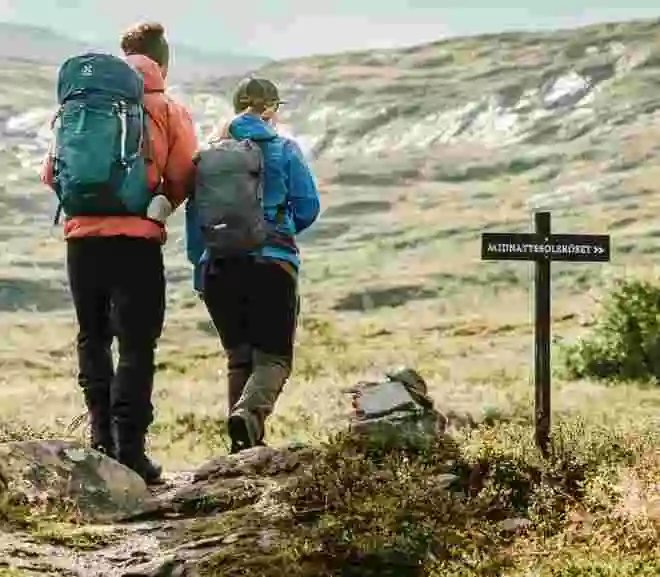
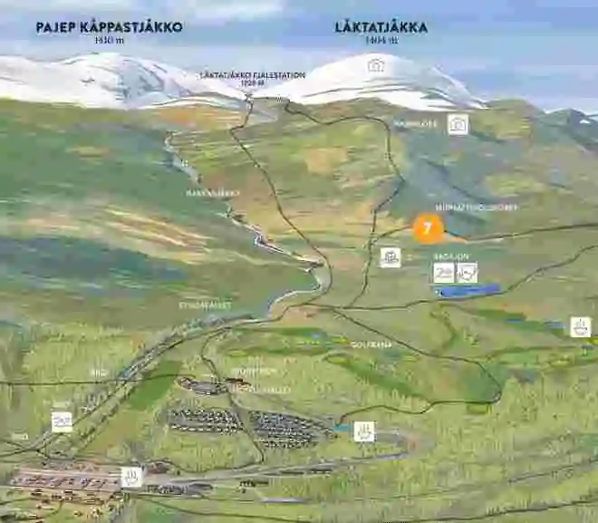
There are two alternative trails up to the hut: the “Färdledarvägen” (Guide’s Trail) and the “Sommarleden” (Summer Trail). Both are marked with cairns (i.e., standing stones with red painted dots).

The Guide’s Trail is a bit steeper up Mount Namnlösa, but in return, you are rewarded with spectacular views towards Vadvetjåkka National Park to the northwest. The Summer Trail is a bit gentler in its ascent, and along it, you can also see remnants from when Låktatjåkko Mountain Station was built in the form of railway sleepers that were laid out to transport building materials.

Both trails are marked with red dots on Calazo and Lantmäteriet’s maps. The Guide’s Trail is the northern one, and the Summer Trail is the southern one. Early in the season, the Summer Trail can be very wet in places and should then be avoided. Ask at the reception if you would like advice on which route to take.

THE TRAILS TO LÅKTA

5. The Unnamed Peak (Namnlösa toppen)

An often-overlooked gem is the mountain “Namnlösa” (The Unnamed Peak). Few peaks in the area offer such a fantastic view of the surrounding landscape, and you’d be hard-pressed to find a better spot to enjoy the midnight sun. This tour begins in the mountain birch forest or the low-alpine region, believed to be the oldest type of forest in Scandinavia. Where the mountain birch forest ends, the mid- and high-alpine regions begin. The boundary is usually drawn where blueberry bushes cease to grow. The mid- and high-alpine regions are characterized by grassy heaths that transition into increasingly rocky terrain with sparser and sparser vegetation.

”At very high altitudes, only lichens can survive. Keep an eye out for the Glacier Buttercup (Isranunkeln), which also thrives at high altitudes!”

To get up to Namnlösa, start at the hotel and follow the trail towards Låktatjåkko Mountain Station. When you turn off from the golf course and start to gain a little elevation, the ascent onto Namnlösa begins. The trail to Låktatjåkko Mountain Station divides here into the Summer Trail (Sommarleden) and the Guide’s Trail (Färdledarvägen). Both trails are marked with red dots on the map (BD6). We suggest you choose the Summer Trail, which is the southern route. It has a slightly gentler ascent up Namnlösa. Once you’ve reached the mountain plateau Rákkasláhku, after about 2.5 km, and the trail starts to slope slightly downwards, instead of continuing on the trail, you should turn off and go directly north up onto Namnlösa itself. From the trail to the summit, approximately 700 meters and 30 meters of elevation remain.

    FACTS

    Distance:

       About 3,5 km (one-way)

    Time required:

       3 h

    Marking:

       Björkliden – Namnlösa                

    Elevation gain:

       About 400 m.

6. Flower Trail (Blomsterstigen)

Are you keen to simply enjoy nature and learn more about the plants in our area? Then our Flower Trail is perfect. The trail takes you to some of our most beautiful spots in the immediate vicinity of Björkliden while teaching you about the plants you see. Tip! Bring a flora guide.

The tour starts at the sports shop, where you can borrow a compendium. In the compendium, you’ll find pictures and descriptions of over 50 plants, where they are most likely to be seen, and a detailed tour description. The flower hike is one of the most pleasant walks you can take in the immediate area, and it leads you through all our terrain types: barren forest, water, bare mountain, and lush birch forest. When you’re back home, please return the compendium so we can save paper.

    FACTS

    Distance:

       2 km.

    Time required:

       1 – 2 h.

    Marking:

    The trail is marked with flower decals.

    Elevation gain:

       About 50 m.

7. Midnight Sun Cairn (Midnattssolsröset)

Hike up to our Midnight Sun Cairn and sign our guestbook. Up here, you can enjoy the beautiful view and the sun at midnight. This is, of course, a nice trip to do at other times of the day and year as well. At the stroke of midnight, the sun stands directly over Pålnoviken in Torneträsk and the Norwegian Sördalen, which is a canyon with steep cliff faces.

You start at the hotel and walk up the gravel road towards the golf course and the first tee. Continue up the gravel road to a small information sign about Låktatjåkko Mountain Station in English. This tour is also described here. Follow this clear path with red-marked cairns that goes to the left from the gravel road. After about 500 m, the cairns are marked with red and yellow. Follow the yellow marking that turns off to the right. You will soon see the hill with a cairn and a sign on it. You’ll cross some slightly wetter areas, and then you’ve arrived. When you go back, you can keep to the right, closer to the stream, to pass by Syndafallet (The Sin’s Fall).

    FACTS

    Distance:

       Hotel – Midnight Sun Cairn and back, 3.5 km.

    Time required:

       1-1.5 h

    Marking:

      Cairns with red paint, then with yellow paint, and signs.

8. The Sin’s Fall and The View (Syndafallet och utsikten)

Hike up the hill behind the hotel, and you’ll immediately be on the bare mountain (kalfjället). Drink the clear, fresh water from Rakkasjohka stream. A mountain panorama spreads out around you, and if you’re lucky, you might spot some reindeer grazing on the mountain heath.

Start at the hotel and aim for the trail towards Låktatjåkko Mountain Station. After you’ve passed the golf course’s first tee by about 50 meters, look for a path on your left side. Take this path down towards Rakkasjohka; you’ll soon arrive at Syndafallet (The Sin’s Fall). Take the opportunity to drink a gulp of the good, fresh water, then follow the path the last few meters up onto the bare mountain plateau. Here you’ll rejoin the trail towards Låktatjåkko, take it in the direction back down towards the hotel. Soon you’ll be back on a well-trodden gravel path; you can follow this up towards the bathing lake if you wish. Otherwise, turn downwards and aim for a hill. Also, be sure to get that classic photo of Lapporten! The gravel road will then take you back down towards the hotel.

    FACTS

    Distance:

       2-3 km for the entire hike, depending on the chosen route.

    Time required:

       1 h.

    Marking:

      None – but a clear path.

9. Day Trip up to Njúlla

Do you crave a slightly longer adventure with miles of expansive views? Then a trip to Mount Njulla is unbeatable. It’s a hike that takes you through most of the terrain types the mountains have to offer. First, lush birch forest with bubbling streams, then rocky canyons and streams, and finally the bare mountain, where it’s initially more bushy with dwarf birch, lingonberry, and blueberry, becoming increasingly stony the closer you get to the summit. If you make it all the way to the top, your legs will have carried you a full 750 meters upwards in elevation.

You start at the hotel and follow the path that crosses Teknikbacken behind the hotel. You follow the path past Lavvon, down to Rakkasjohka stream, and over the bridge. On the other side of the bridge, you follow the path, and after about 1 km, you’ll reach a gravel road. Follow it for 300 m until you come to a wooden fence and an open area. You cross the open area and follow the path that leads up into the birch forest. Continue along the path upwards until you reach a bridge over Gohpasjohka stream. Cross the bridge, and you’ll have the summit directly in front of you, but the path will take you to the right, up and around to the summit, so the ascent isn’t too steep. Once you’ve reached the top, you can choose to hike back down to Björkliden or continue towards Abisko and take the Rallarvägen (Navvy Trail) home.

    FACTS

    Distance:

       6,5 km.

    Elevation gain:

       750 m.

    Marking:

      Red markings on the trees up to the bridge at Gohpasjohka, then a clear path.